(NEW YORK) — Tropical Storm Arthur, the first named storm of the Atlantic hurricane season, weakened overnight but its energy is still powerful enough to cause serious flooding and other issues in the southeast Thursday.
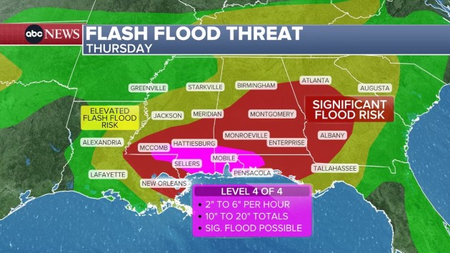
A rare High Risk, level 4 of 4, for life-threatening flood potential was in place over southern Mississippi, southern Alabama and western Florida panhandle along the central Gulf Coast Thursday, according to the National Weather Service (NWS).
Historically, a third of all flood-related fatalities and 80% of all flood-related damages occur in such high-risk areas, according to NWS data.
Areas under the High Risk advisory include Pensacola, Florida; Mobile, Alabama; and the Mississippi cities of Gulfport, McComb and Hattiesburg.
Rainfall rates of multiple inches per hour are possible, and some areas could see up to 20 inches of rainfall accumulation.
A flash flood emergency was issued for Picayune, Mississippi, where 3 to 5 inches of rain had fallen by late Thursday morning. Another flash flood emergency was issued for southern Avoyelles Parish in Louisiana, where 8 to 12 inches of rain had fallen, while a third flash flood emergency was issued later in Stone County, Mississippi, where 6 to 10 inches of rain fell by noon.
Extremely heavy rain already hit the Gulf states Thursday morning. Kenner, Louisiana, near the New Orleans airport, saw a radar estimated rainfall rate of 6.5 inches per hour.
Some Gulf areas are under a level 3 of 4 risk for flooding, including Montgomery, Alabama, and Atlanta, Georgia.
Tornadoes are also possible in the central Gulf Coast Thursday.
The life-threatening flood threat will continue into the overnight hours and people need to remain aware of their flood risk overnight into early Friday morning, forecasters warn.
More heavy rain will continue in the South on Friday and more sporadically on Saturday.
Copyright © 2026, ABC Audio. All rights reserved.